Introduction
Severe weather conditions related to tornado warning have been making headlines recently, with record-breaking temperatures and dangerous storms affecting various regions. From Birmingham to Tuscaloosa and Montgomery, the heat has intensified, creating the perfect conditions for severe weather. This article will delve into the recent tornado warnings, the science behind these extreme weather events, and what to expect in the coming days.
The Connection Between Heat and Severe Storms
The sweltering temperatures recorded across Alabama and other parts of the southeastern United States have played a crucial role in fueling severe weather systems.
Key Factors Contributing to Severe Weather:
- High Temperatures: Warm air holds more moisture, leading to intense storms.
- Strong Winds: Gusty conditions create instability, a crucial ingredient for thunderstorms.
- High Pressure Systems: These can suppress storm development in some areas while intensifying it in others.
The storms brewing in northeastern Arkansas and western Tennessee have already led to numerous tornado warnings, some of which have been confirmed. With the storm tracking eastward towards Memphis, residents must stay vigilant and prepared.
Tornado Warnings: A Rare High-Risk Day
Meteorologists classify storm threats on a scale from one to five, with five being the highest risk level. High-risk warnings are rare and indicate a likelihood of long-lived, intense tornadoes.
What Makes This Event Significant?
- Historical Context: Only six high-risk days have been issued in the past five to six years.
- Geographic Impact: The Mississippi River region, Tennessee, and Arkansas face the most significant threats.
- Tornado Intensity: Some tornadoes are strong enough to be classified as emergency warnings.
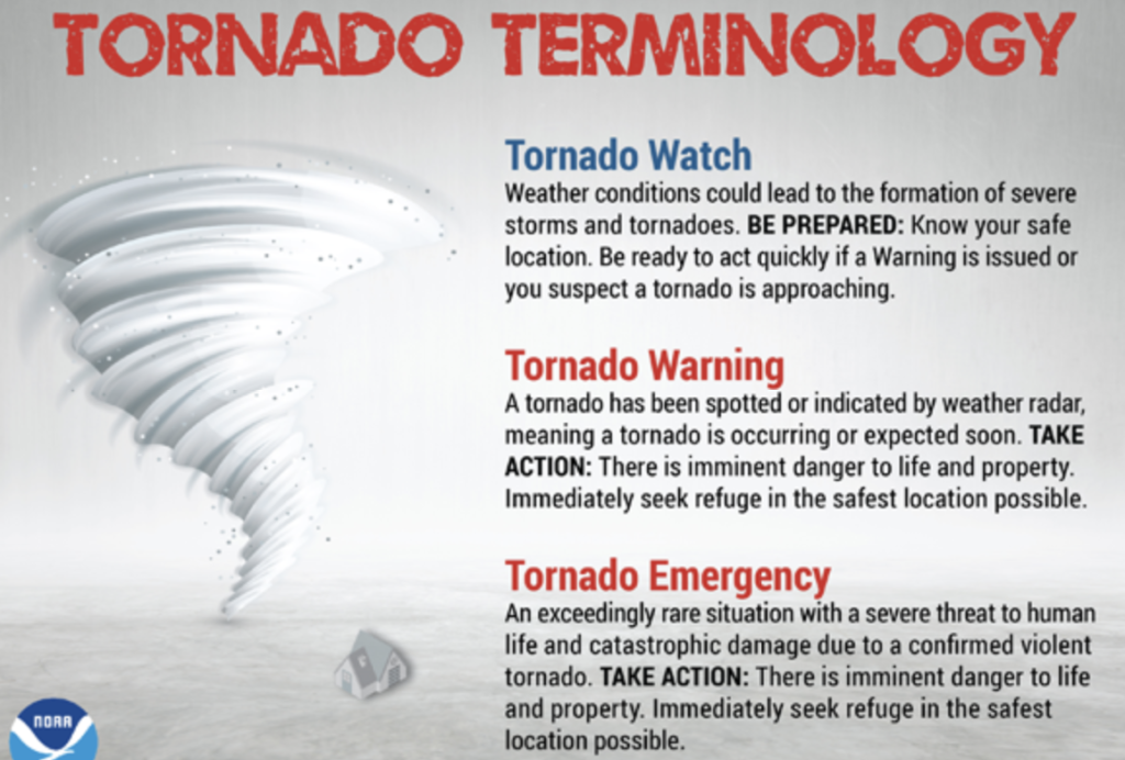
Understanding Tornado Warnings and Radar Readings
Meteorologists use radar to detect tornadoes, identifying strong wind velocities and rotation within storm systems.
Types of Tornado Warnings:
- Standard Tornado Warning: Indicates a tornado has been spotted or detected on radar.
- Emergency Tornado Warning: Issued for exceptionally strong tornadoes, as seen recently in Lake City.
- Severe Thunderstorm Warning: Often precedes tornado formation and can cause damaging winds and hail.
A notable aspect of the recent storms is the radar readings, which show bright tan and orange colors, indicating exceptionally high wind velocities. This suggests the presence of powerful tornadoes.
The Role of High-Pressure Systems in Weather Patterns
High-pressure systems play a significant role in steering storms. Currently, a high-pressure system is protecting Alabama, preventing severe storms from reaching the region. This system acts as a barrier, pushing storms away and creating a clockwise motion.
However, while Alabama may avoid the brunt of this severe weather, isolated storms with strong winds and hail remain a possibility in some areas, including:
- Northwest Alabama (Haleyville, Bear Creek, Jasper, Fayette)
- Regions near the Tennessee border
What to Expect in the Coming Days
Short-Term Weather Outlook:
- Tonight: Some isolated storms may develop in northwestern Alabama but are unlikely to be severe.
- Tomorrow & Thursday: Severe weather is expected to continue northward from Little Rock to Cincinnati, with Alabama largely remaining unaffected.
- Sunday: Heavy storms are likely, particularly before 1-2 PM.
- Risk Level: Low to moderate chance of severe weather.
- Main Threats: Strong winds and heavy rainfall.
Long-Term Forecast:
After the weekend storms, a dramatic shift in temperatures is expected.
- From Summer to Early March-Like Conditions: A drop in temperatures will bring cooler air, with the possibility of scattered frost next week.
How to Stay Safe During Severe Weather
Given the increased frequency of extreme weather events, preparation is key. Here are some essential safety tips:
Before a Tornado:
- Stay informed by monitoring local weather updates and alerts.
- Identify a safe shelter area, preferably a basement or an interior room without windows.
- Prepare an emergency kit with essentials like water, food, flashlights, and a first-aid kit.
During a Tornado:
- Seek shelter immediately in a sturdy building.
- Avoid windows and doors; cover yourself with a mattress or heavy blanket.
- Listen to emergency broadcasts for updates and instructions.
After a Tornado:
- Avoid downed power lines and debris.
- Check on neighbors and offer assistance if needed.
- Contact local authorities for updates on road closures and emergency relief efforts.
External Resources for Further Reading
To better understand severe weather and tornado preparedness, consider these authoritative sources:
- National Weather Service – Tornado Safety
- The Weather Channel – Severe Weather Updates
- FEMA – Disaster Preparedness Guide
- American Red Cross – Emergency Preparedness
- NOAA – Climate and Weather Patterns
Conclusion
Severe weather events, such as the recent tornado warnings in Arkansas and Tennessee, highlight the importance of preparedness and awareness. While Alabama remains shielded by high pressure for now, upcoming storms could still pose risks. Staying informed, having an emergency plan, and understanding weather patterns are essential for safety.
As weather conditions continue to change rapidly, keeping an eye on forecasts and heeding warnings from meteorologists will help communities stay safe. Be prepared, stay vigilant, and prioritize safety above all else.
Stay Safe & Stay Informed!
If you found this article helpful, share it with your friends and family to ensure they are prepared for severe weather events. For more updates, follow our blog and stay connected with reliable weather sources.
Politics – Globyte News
Nice post. I learn something totally new and challenging on websites